| Time |
Distance |
Instruction |
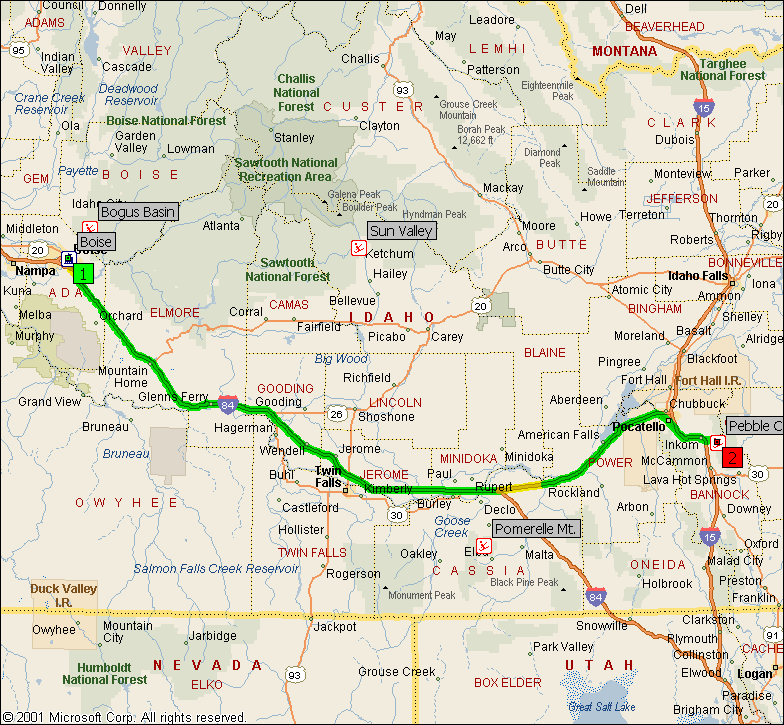
| 12:00 PM | 0.0 | 1 Depart Boise on US-20 [Front St] (North-West) for 0.1 mi |
| 12:00 PM | 0.1 | Turn LEFT (South) onto S 14th St for 142 yds |
| 12:01 PM | 0.2 | Turn LEFT (South-East) onto US-20 [Borah St] for 4.1 mi |
| | Interchange Reconstruction near Boise from 07/01/02 to 11/25/02 |
| 12:07 PM | 4.3 | Turn LEFT (East) onto Ramp for 0.1 mi |
| | Resurfacing in Boise from 06/03/02 to 11/29/02 |
| 12:07 PM | 4.4 | Merge onto I-84 [US-26] (South-East) for 167.0 mi |
| | Resurfacing in Boise from 06/03/02 to 11/29/02 |
| 2:41 PM | 171.4 | At I-84 Exit 222, turn off onto Ramp for 0.3 mi |
| 2:41 PM | 171.8 | Merge onto I-86 [US-30] (East) for 57.8 mi |
| | Construction in Cotterel from 02/04/02 to 10/11/02 |
| 3:35 PM | 229.6 | At I-86 Exit 58, turn off onto Ramp for 0.3 mi |
| 3:35 PM | 229.9 | Bear RIGHT (South-East) onto US-30 for 8.0 mi |
| 3:46 PM | 237.8 | Continue (South-East) on Ramp for 0.4 mi |
| 3:47 PM | 238.3 | Merge onto I-15 [US-30] (South) for 8.8 mi |
| 3:55 PM | 247.1 | At I-15 Exit 58, turn off onto Ramp for 0.1 mi |
| 3:55 PM | 247.2 | Merge onto I-15 Bus [US-91 Bus] (South) for 2.2 mi |
| 3:58 PM | 249.3 | Turn LEFT (East) onto Inkom Rd for 0.3 mi |
| 3:59 PM | 249.6 | Turn RIGHT (East) onto Green Canyon Rd for 3.5 mi |
| 4:03 PM | 253.2 | Bear LEFT (South-East) onto Local road(s) for 0.2 mi |
| 4:04 PM | 253.4 | 2 Arrive Pebble Creek |
Copyright © 1988-2001 Microsoft Corp. and/or its suppliers. All rights reserved. http://www.microsoft.com/mappoint
© Copyright 2000 by Geographic Data Technology, Inc. All rights reserved.
© 2000 Navigation Technologies. All rights reserved. This data includes information taken with permission from Canadian authorities © Her Majesty the Queen in Right of Canada
© Copyright 2000 by Compusearch Micromarketing Data and Systems Ltd.